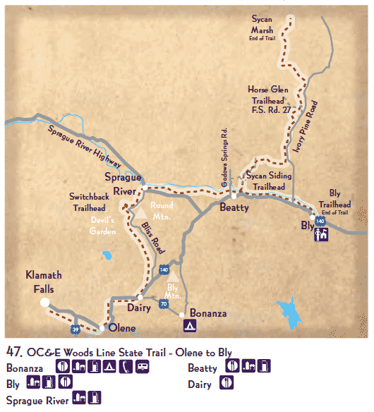
Near Highway 140 east of Klamath Falls, Oregon from the community of Olene to the Town of Bly.
About 56 miles of unpaved trail run from Olene to the small town of Bly. An additional 34-mile spur called the Woods Lineconnects near Beatty, and travels N to the Sycan Marsh area. This linear trail runs through a mix of agricultural land, sagebrush/juniper habitats intermixed with grassland and ponderosa pine and other conifers. Near Olene, the trail provides views into riparian areas of the Lost River (see #32).
Juniper/Oak Titmouse, Townsend's Solitaire, Mountain Bluebird, Spotted Towhee, Red-breasted Nuthatch, Western Tanager, Black-headed Grosbeak. Sycan Marsh may provide opportunities to see Sandhill Cranes as well as a variety of shorebirds and waterfowl particularly during the spring and summer months.
From Klamath Falls, take Hwy 140 to the unincorporated community of Olene. A number of other trail access points are available including access areas with parking at the Switchback Trailhead near the community of Sprague River, at the Sycan Shops near Beatty and the town of Bly (along Hwy 140 E of Klamath Falls). GPS: 121° 14' 34.91" W, 42° 26' 45.61" N. ( 121° 37' 28.65" W, 42° 10' 38.25" N)
Klamath Rails-to-Trails Group
Box 2102
Klamath Falls, OR 97601
Collier Memorial State Park
46000 Highway 97 N
Chiloquin, OR 97624
Phone: (541) 783-2471
Oregon State Parks: www.oregonstateparks.org/park_230.php
Klamath Rails-to-Trails: www.klamath-trails.org
You are here: Home > Birding Sites > Trail Map > 47. OC&E Woods Line State Trail
Next and Previous Site: 46. Gerber Recreation Area < 47. OC&E Woods Line State Trail